
Дѣло:Balkans05.png

Size of this preview: 650 × 599 пиѯєлъ. Other resolutions: 260 × 240 пиѯєлъ | 521 × 480 пиѯєлъ | 833 × 768 пиѯєлъ | 1.128 × 1.040 пиѯєлъ.
источьнъ дѣла обраꙁъ (1.128 × 1.040 п҃ѯ · дѣла мѣра : 130 Х҃Б · MIME тѷпъ : image/png)
| Сь видъ Викикладѣ (Wikimedia Commons) съхранѥнъ ѥстъ ⁙ Cѥ ѥгожє опьсаниѥ ѥстъ |
опьсаниѥ
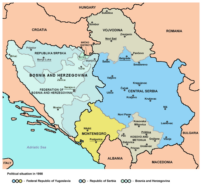
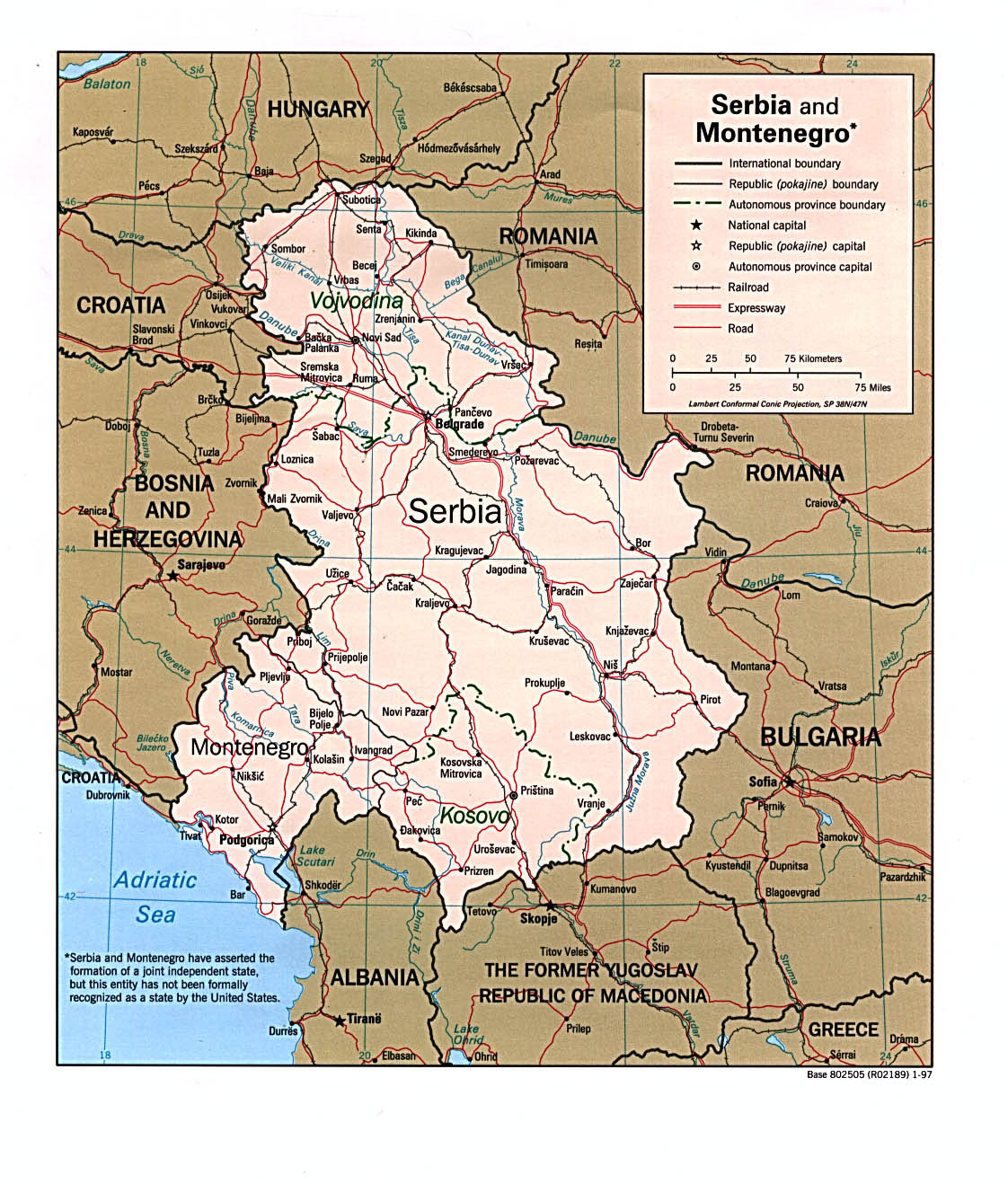
Map of Federal Republic of Yugoslavia and Bosnia and Herzegovina in 1998.
Source and licence
- Source: English Wikipedia, en:Image:Balkans05.png (author of the map was User:PANONIAN)
| |
This work has been released into the public domain by its author, PANONIAN, at the а҆нглі́йскїй Википєдїꙗ project. This applies worldwide. In case this is not legally possible: |
References
- Geografski atlas, Magic Map, Smederevska Palanka, 2001.
- Denis Šehić - Demir Šehić, Geografski atlas Srbije, Beograd, 2007.
- Školski geografski atlas, Intersistem Kartografija, Beograd, 2001.
- Geografski atlas, Intersistem Kartografija, Beograd, 2004.
- Geografski atlas, Geokarta, Beograd, 2002.
- Ljiljana Popović - Vlado Jarčov, Geografski atlas sveta, Beograd, 2002.
- http://i.infoplease.com/images/myugo.gif
- http://www.aboutromania.com/SerbiaAndMontenegroMap.gif
- http://www.vidiani.com/maps/maps_of_europe/maps_of_serbia/relief_and_administrative_map_of_serbia_and_montenegro.jpg
- http://www.vidiani.com/maps/maps_of_europe/maps_of_serbia/road_map_of_serbia_and_montenegro.jpg
- http://www.zonu.com/images/0X0/2009-09-18-7067/Mapa-Politico-de-los-Balcanes-Occidental-2003.jpg
- http://www.srpska-mreza.com/MAPS/Bosnia/DaytonBosnia.jpg
- http://www.history-map.com/picture/000/pictures/agreement-ceasefire-Dayton-and.jpg
- http://www.history.army.mil/brochures/Bosnia-Herzegovina/images/Map2sm.jpg archive copy at the Wayback Machine
дѣла їсторїꙗ
Click on a date/time to view the file as it appeared at that time.
| дьнь / врѣмѧ | малъ обраꙁъ | мѣра | польꙃєватєл҄ь | опьсаниѥ | |
|---|---|---|---|---|---|
| нꙑнѣщьн҄ь обраꙁъ | 23:01, аѷгоуста 26 числа, 2021 | | 1.128 × 1.040 (130 Х҃Б) | Santasa99 | more npov on colors & labels |
| 13:39, апрїлїꙗ 27 числа, 2012 |  | 1.128 × 1.040 (114 Х҃Б) | PANONIAN | improved version | |
| 14:39, октѡврїꙗ 25 числа, 2005 |  | 711 × 600 (209 Х҃Б) | Nascigl | Origem: Wikipédia em inglês map of Serbia and Montenegro and Bosnia and Herzegovina {{PD}} |
дѣла польꙃєваниѥ
The following page uses this file:
Global file usage
инꙑ мѣста къдє сѥ дѣло польꙃєвано ѥстъ :
- польꙃєваниѥ въ an.wikipedia.org
- польꙃєваниѥ въ ar.wikipedia.org
- польꙃєваниѥ въ ast.wikipedia.org
- польꙃєваниѥ въ ba.wikipedia.org
- польꙃєваниѥ въ be-tarask.wikipedia.org
- польꙃєваниѥ въ be.wikipedia.org
- польꙃєваниѥ въ bg.wikipedia.org
- польꙃєваниѥ въ ca.wikipedia.org
- польꙃєваниѥ въ cs.wikipedia.org
- польꙃєваниѥ въ en.wikipedia.org
- польꙃєваниѥ въ eo.wikipedia.org
- польꙃєваниѥ въ es.wikipedia.org
- польꙃєваниѥ въ et.wikipedia.org
- польꙃєваниѥ въ fa.wikipedia.org
- польꙃєваниѥ въ fi.wikipedia.org
- польꙃєваниѥ въ fr.wikipedia.org
- польꙃєваниѥ въ gl.wikipedia.org
- польꙃєваниѥ въ he.wikipedia.org
- польꙃєваниѥ въ hi.wikipedia.org
- польꙃєваниѥ въ hu.wikipedia.org
- польꙃєваниѥ въ it.wikipedia.org
- польꙃєваниѥ въ ja.wikipedia.org
- польꙃєваниѥ въ ka.wikipedia.org
- польꙃєваниѥ въ ko.wikipedia.org
- польꙃєваниѥ въ la.wikipedia.org
- польꙃєваниѥ въ lt.wikipedia.org
- польꙃєваниѥ въ mk.wikipedia.org
- польꙃєваниѥ въ myv.wikipedia.org
- польꙃєваниѥ въ nl.wikipedia.org
- польꙃєваниѥ въ no.wikipedia.org
- польꙃєваниѥ въ oc.wikipedia.org
- польꙃєваниѥ въ pl.wikipedia.org
- польꙃєваниѥ въ pnb.wikipedia.org
- польꙃєваниѥ въ pt.wikipedia.org
- польꙃєваниѥ въ ru.wikipedia.org
- польꙃєваниѥ въ sh.wikipedia.org
- польꙃєваниѥ въ simple.wikipedia.org
View more global usage of this file.