
Дѣло:People's Republic of China (orthographic projection).svg

Size of this PNG preview of this SVG file: 541 × 541 пиѯєлъ. Other resolutions: 240 × 240 пиѯєлъ | 480 × 480 пиѯєлъ | 768 × 768 пиѯєлъ | 1.024 × 1.024 пиѯєлъ | 2.048 × 2.048 пиѯєлъ.
источьнъ дѣла обраꙁъ (дѣло SVG · обꙑчьнъ обраꙁъ : 541 × 541 п҃ѯ · дѣла мѣра : 260 Х҃Б)
| Сь видъ Викикладѣ (Wikimedia Commons) съхранѥнъ ѥстъ ⁙ Cѥ ѥгожє опьсаниѥ ѥстъ |
опьсаниѥ
| опьсаниѥ |
Italiano: La Repubblica Popolare Cinese (in verde) e il territorio da essa dichiarato (in verde chiaro).
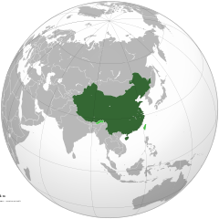
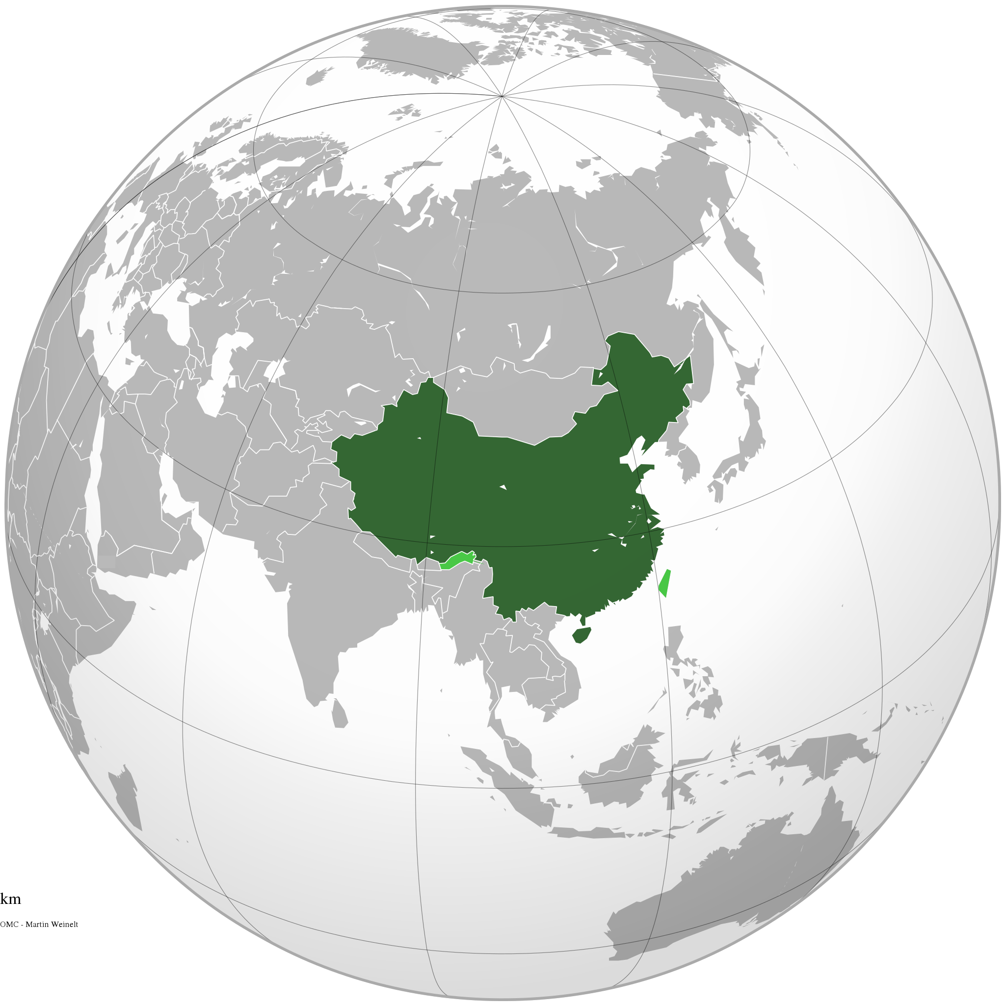
English: The People's Republic of China (green) and its claimed territory (lighter green).
Русский: Китайская Народная Республика (зелёный).
Українська: Територія Китаю позначена зеленим. Територія, на яку претендує Китай, але не контролює її, позначена світло-зеленим.
中文(简体):中华人民共和国(深绿色)及其认为拥有主权的地区(浅绿色)。
中文(繁體):中華人民共和國(深綠色)及其自認為擁有主權的地區(淺綠色)。 |
||||
| врѣмѧ сътворѥниꙗ | |||||
| кладѧꙃь |
своѥ творѥниѥ (Original text: Own work)
|
||||
| творьць | Ssolbergj | ||||
| Other versions |
.svg)
|
||||
| SVG genesis |
.jpg)
.svg)
.svg)
.svg)
.svg)
.svg)
.svg)
.svg)
.svg)
.svg)
.svg)
.svg)
.svg)
.svg)
.svg)
.svg)
.svg)
.svg)
.svg)
.svg)
.svg)
.svg)
.svg)
.svg)
.svg)
.svg)
.svg)
.svg)
.svg)
.svg)
.svg)
.svg)
.svg)
.svg)
.svg)
.svg)
.svg)
.svg)
.svg)
.svg)
.svg)
.svg)
.svg)
.svg)
.svg)
.svg)
.svg)
.svg)
.svg)
.svg)
.svg)
.svg)
.svg)
.svg)
.svg)
.svg)
.svg)
.svg)
.svg)
.svg)
.svg)
.svg)
.svg)
.svg)
.svg)
.svg)
.svg)
.svg)
.svg)
.svg)
.svg)
.svg)
.svg)
.svg)

.svg)

.svg)

.svg)
.svg)
.svg)
.svg)
.svg)
.svg)
.svg)


.svg)
.svg)
.svg)
.svg)
.svg)
.svg)
.svg)

.svg)
.svg)
.svg)
.svg)
.svg)
.svg)
.svg)
.svg)
.svg)

.svg)
.svg)
.svg)
.svg)
.svg)
.svg)
.svg)
_without_national_boundaries.svg)
.svg)
.svg)
.svg)
.svg)
.svg)
.svg)

.svg)
.svg)
.png)
.svg)
.svg)
.svg)
.svg)

.svg)
.svg)
.svg)
.svg)
.svg)
.svg)
.svg)
.svg)
.svg)
.svg)
.svg)

.svg)
.svg)
.svg)
.svg)
.svg)
.svg)
.svg)
.svg)
.svg)

.svg)
.svg)

.svg)
.svg)
.svg)
.svg)
.svg)
.svg)
.svg)
.svg)
.svg)
.svg)
.svg)
.svg)
.svg)
.svg)
.svg)
.svg)
.svg)
.svg)
.svg)
.svg)
.svg)
.svg)
.svg)
.svg)
.svg)
.svg)
.svg)
_-_Crimea_disputed.svg)
.svg)
.svg)
.svg)
.svg)
.svg)
.svg)
.svg)
.svg)
.svg)
.svg)
.svg)
_political.svg)
.svg)
.svg)
.svg)
.svg)
_-_Crimea_disputed_-_no_borders.svg)
.svg)
.svg)
.svg)
.svg)
.svg)
.svg)
.svg)
.svg)
.svg)
.svg)
.svg)

.svg)
.svg)
.svg)

.png)
.svg)
.svg)
.svg)
.svg)
.svg)
.svg)
.svg)
.svg)
.svg)
.svg)
.svg)
.svg)
.svg)
.svg)
.svg)
.svg)
.svg)
.svg)
.svg)
.svg)
.svg)
.svg)
.svg)
.svg)
.svg)
.svg)
.svg)
.svg)
.svg)
.svg)
.svg)
.svg)
.svg)
.svg)
.png)
.svg)
.svg)
.svg)
_(orthographic_projection).png)
.svg)
.svg)
.svg)
.svg)
прощєниѥ
I, the copyright holder of this work, hereby publish it under the following licenses:

|
Permission is granted to copy, distribute and/or modify this document under the terms of the GNU Free Documentation License, Version 1.2 or any later version published by the Free Software Foundation; with no Invariant Sections, no Front-Cover Texts, and no Back-Cover Texts. A copy of the license is included in the section entitled GNU Free Documentation License. |
This file is licensed under the Creative Commons Attribution-Share Alike 4.0 International, 3.0 Unported, 2.5 Generic, 2.0 Generic and 1.0 Generic license.
- тꙑ можєши :
- прострѣти – to copy, distribute and transmit the work
- прѣвращати – прѣтворити дѣло
- Under the following conditions:
- attribution – You must give appropriate credit, provide a link to the license, and indicate if changes were made. You may do so in any reasonable manner, but not in any way that suggests the licensor endorses you or your use.
- share alike – ащє жє сѥ дѣло иꙁмѣниши · прѣвратиши или ѥгожє основѣ нѣчьто сътвориши · тъ авлѥно слѣдьствиѥ подъ самомь тѣмь прощєниѥмь или подобьномь ѥмоу положити длъжєнъ ѥси
прощєниѥ иꙁбрати можєши
дѣла їсторїꙗ
Click on a date/time to view the file as it appeared at that time.
.svg&dir=prev)
.svg&offset=20111111220409)
.svg&offset=&limit=20)
.svg&offset=&limit=50)
.svg&offset=&limit=100)
.svg&offset=&limit=250)
.svg&offset=&limit=500)
| дьнь / врѣмѧ | малъ обраꙁъ | мѣра | польꙃєватєл҄ь | опьсаниѥ | |
|---|---|---|---|---|---|
| нꙑнѣщьн҄ь обраꙁъ | 15:16, дєкємврїꙗ 29 числа, 2019 | | 541 × 541 (260 Х҃Б) | Goran tek-en | Added border for South Sudan as requested by Maphobbyist |
| 06:05, апрїлїꙗ 25 числа, 2014 |  | 541 × 541 (142 Х҃Б) | Chipmunkdavis | Rv removal of claimed territories | |
| 16:05, апрїлїꙗ 23 числа, 2014 |  | 541 × 541 (498 Х҃Б) | Lawson123 | Reverted to version as of 17:14, 15 March 2014 | |
| 19:13, мартїꙗ 15 числа, 2014 |  | 541 × 541 (142 Х҃Б) | Chipmunkdavis | Rv removal of claimed territories | |
| 17:14, мартїꙗ 15 числа, 2014 |  | 541 × 541 (498 Х҃Б) | Semidwarf | Reverted to version as of 20:49, 14 March 2014 | |
| 00:14, мартїꙗ 15 числа, 2014 |  | 541 × 541 (142 Х҃Б) | Chipmunkdavis | Rv removal of claimed territories | |
| 20:49, мартїꙗ 14 числа, 2014 |  | 541 × 541 (498 Х҃Б) | Semidwarf | Reverted to version as of 14:49, 9 April 2011 | |
| 20:48, мартїꙗ 14 числа, 2014 |  | 541 × 541 (498 Х҃Б) | Semidwarf | Reverted to version as of 14:49, 9 April 2011 | |
| 21:53, сєптємврїꙗ 12 числа, 2012 |  | 541 × 541 (142 Х҃Б) | Palosirkka | Scrubbed with http://codedread.com/scour/ | |
| 22:04, ноємврїꙗ 11 числа, 2011 |  | 541 × 541 (481 Х҃Б) | Gucong | According to http://en.wikipedia.org/wiki/Wikipedia:WikiProject_Maps/Conventions/Orthographic_maps , claimed areas shall be marked as light green |
дѣла польꙃєваниѥ
The following page uses this file:
Global file usage
инꙑ мѣста къдє сѥ дѣло польꙃєвано ѥстъ :
- польꙃєваниѥ въ af.wikipedia.org
- польꙃєваниѥ въ ami.wikipedia.org
- польꙃєваниѥ въ arc.wikipedia.org
- польꙃєваниѥ въ ar.wikipedia.org
- польꙃєваниѥ въ as.wikipedia.org
- польꙃєваниѥ въ av.wikipedia.org
- польꙃєваниѥ въ azb.wikipedia.org
- польꙃєваниѥ въ az.wikipedia.org
- польꙃєваниѥ въ az.wiktionary.org
- польꙃєваниѥ въ ban.wikipedia.org
- польꙃєваниѥ въ ba.wikipedia.org
- польꙃєваниѥ въ bcl.wikipedia.org
- польꙃєваниѥ въ beta.wikiversity.org
- польꙃєваниѥ въ be.wikipedia.org
- польꙃєваниѥ въ bh.wikipedia.org
- польꙃєваниѥ въ bn.wikipedia.org
- польꙃєваниѥ въ cdo.wikipedia.org
- польꙃєваниѥ въ cs.wikipedia.org
- польꙃєваниѥ въ da.wikipedia.org
- польꙃєваниѥ въ de.wiktionary.org
- польꙃєваниѥ въ dty.wikipedia.org
- польꙃєваниѥ въ dz.wikipedia.org
- польꙃєваниѥ въ el.wikipedia.org
- польꙃєваниѥ въ el.wikinews.org
- Το Διεθνές Νομισματικό Ταμείο προειδοποεί τη Κίνα για το γουάν
- Πρότυπο:Κίνα
- Ατύχημα με 41 νεκρούς στη Κίνα
- Κίνα: Η στήριξη της Ελλάδας αποτελεί σημαντικό βήμα για την Ευρωζώνη
- Συνεχίζονται οι απεργίες των ταξί στη Κίνα
- Πενηντατέσσερις αμαξοστοιχίες ανακαλούνται στην Κίνα για λόγους ασφαλείας
- Η Coca-Cola θα επενδύσει 4 δισεκατομμύρια δολάρια στη Κίνα για τα επόμενα 3 έτη
- Διασώθηκαν 19 παγιδευμένοι ανθρακωρύχοι στη Κίνα
- Ήπια ενίσχυση της μεταποίησης στη Κίνα
- Δέκα ανθρακωρύχοι ανασύρθηκαν νεκροί από ορυχείο της Κίνας
- Ανακαλύφθηκε τάφος με 12 άλογα στη Κίνα
- Έντεκα άτομα σκοτώθηκαν σε ναυάγιο στη Κίνα
- Κίνα: Δεκάδες νεκροί και αγνοούμενοι ύστερα από ισχυρές βροχοπτώσεις
- Κρούσματα πολιομυελίτιδας στην Κίνα για πρώτη φορά από το 1999
- Στη Κίνα συνελήφθη άνδρας που βίαζε στο υπόγειο έξι γυναίκες για δύο χρόνια
- Σανγκάη: Εκατοντάδες τραυματίες σε σύγκρουση συρμών του μετρό
- Στην Κίνα ο Βλαντιμίρ Πούτιν
- Στην Κίνα πέταξαν ένα μωρό επειδή το θεώρησαν νεκρό
View more global usage of this file.
.svg)
.svg)