
Дѣло:Balkan Peninsula.svg

Size of this PNG preview of this SVG file: 720 × 600 пиѯєлъ. Other resolutions: 288 × 240 пиѯєлъ | 576 × 480 пиѯєлъ | 922 × 768 пиѯєлъ | 1.229 × 1.024 пиѯєлъ | 2.458 × 2.048 пиѯєлъ | 1.800 × 1.500 пиѯєлъ.
источьнъ дѣла обраꙁъ (дѣло SVG · обꙑчьнъ обраꙁъ : 1.800 × 1.500 п҃ѯ · дѣла мѣра : 295 Х҃Б)
| Сь видъ Викикладѣ (Wikimedia Commons) съхранѥнъ ѥстъ ⁙ Cѥ ѥгожє опьсаниѥ ѥстъ |
опьсаниѥ
| опьсаниѥ |
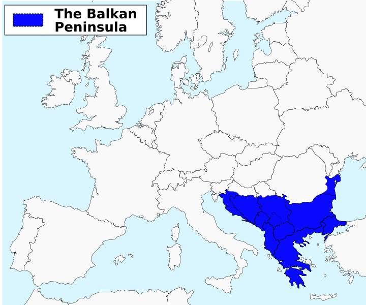
English: The Balkan peninsula as defined by the Danube-Sava-Kupa line. Română: Peninsula Balcanică |
| врѣмѧ сътворѥниꙗ | |
| кладѧꙃь | своѥ творѥниѥ vectorization based on File:Balkanpeninsula.png on Commons |
| творьць | ArnoldPlaton |
| Other versions | Arabic png |
прощєниѥ
I, the copyright holder of this work, hereby publish it under the following license:
сѥ́ дѣ́ло по́дъ прощє́ниѥмь Creative Commons Attribution-Share Alike 3.0 Unported положєно ѥ́стъ
- тꙑ можєши :
- прострѣти – to copy, distribute and transmit the work
- прѣвращати – прѣтворити дѣло
- Under the following conditions:
- attribution – You must give appropriate credit, provide a link to the license, and indicate if changes were made. You may do so in any reasonable manner, but not in any way that suggests the licensor endorses you or your use.
- share alike – ащє жє сѥ дѣло иꙁмѣниши · прѣвратиши или ѥгожє основѣ нѣчьто сътвориши · тъ авлѥно слѣдьствиѥ подъ самомь тѣмь прощєниѥмь или подобьномь ѥмоу положити длъжєнъ ѥси
дѣла їсторїꙗ
Click on a date/time to view the file as it appeared at that time.
| дьнь / врѣмѧ | малъ обраꙁъ | мѣра | польꙃєватєл҄ь | опьсаниѥ | |
|---|---|---|---|---|---|
| нꙑнѣщьн҄ь обраꙁъ | 18:02, маїꙗ 14 числа, 2017 | | 1.800 × 1.500 (295 Х҃Б) | SilentResident | Added missing Greek islands to the map, removed blue color from Euboea Island since it is not part of the Balkan peninsula. |
| 16:40, октѡврїꙗ 19 числа, 2012 |  | 1.800 × 1.500 (294 Х҃Б) | ArnoldPlaton | Thicker lines | |
| 16:31, октѡврїꙗ 19 числа, 2012 |  | 1.800 × 1.500 (294 Х҃Б) | ArnoldPlaton | Font | |
| 16:30, октѡврїꙗ 19 числа, 2012 |  | 1.800 × 1.500 (294 Х҃Б) | ArnoldPlaton | Font, color | |
| 16:28, октѡврїꙗ 19 числа, 2012 |  | 1.800 × 1.500 (279 Х҃Б) | ArnoldPlaton | User created page with UploadWizard |
дѣла польꙃєваниѥ
The following page uses this file:
Global file usage
инꙑ мѣста къдє сѥ дѣло польꙃєвано ѥстъ :
- польꙃєваниѥ въ ace.wikipedia.org
- польꙃєваниѥ въ ar.wikipedia.org
- польꙃєваниѥ въ bn.wikipedia.org
- польꙃєваниѥ въ ca.wikipedia.org
- польꙃєваниѥ въ cs.wikipedia.org
- польꙃєваниѥ въ cv.wikipedia.org
- польꙃєваниѥ въ da.wikipedia.org
- польꙃєваниѥ въ de.wiktionary.org
- польꙃєваниѥ въ el.wikipedia.org
- польꙃєваниѥ въ en.wikipedia.org
- польꙃєваниѥ въ en.wiktionary.org
- польꙃєваниѥ въ eo.wikipedia.org
- польꙃєваниѥ въ es.wikipedia.org
- польꙃєваниѥ въ fa.wikipedia.org
- польꙃєваниѥ въ fi.wikiquote.org
- польꙃєваниѥ въ fo.wikipedia.org
- польꙃєваниѥ въ fr.wikipedia.org
- польꙃєваниѥ въ gl.wikipedia.org
- польꙃєваниѥ въ hak.wikipedia.org
- польꙃєваниѥ въ he.wikipedia.org
- польꙃєваниѥ въ hi.wikipedia.org
- польꙃєваниѥ въ hu.wiktionary.org
- польꙃєваниѥ въ id.wikipedia.org
- польꙃєваниѥ въ it.wikipedia.org
- польꙃєваниѥ въ jam.wikipedia.org
- польꙃєваниѥ въ ja.wikipedia.org
- польꙃєваниѥ въ ja.wiktionary.org
- польꙃєваниѥ въ jv.wikipedia.org
- польꙃєваниѥ въ mk.wikipedia.org
- польꙃєваниѥ въ ml.wikipedia.org
- польꙃєваниѥ въ mn.wikipedia.org
- польꙃєваниѥ въ mr.wikipedia.org
View more global usage of this file.