
Дѣло:Indonesia (orthographic projection).svg

Size of this PNG preview of this SVG file: 550 × 550 пиѯєлъ. Other resolutions: 240 × 240 пиѯєлъ | 480 × 480 пиѯєлъ | 768 × 768 пиѯєлъ | 1.024 × 1.024 пиѯєлъ | 2.048 × 2.048 пиѯєлъ.
источьнъ дѣла обраꙁъ (дѣло SVG · обꙑчьнъ обраꙁъ : 550 × 550 п҃ѯ · дѣла мѣра : 1,79 MB)
| Сь видъ Викикладѣ (Wikimedia Commons) съхранѥнъ ѥстъ ⁙ Cѥ ѥгожє опьсаниѥ ѥстъ |
опьсаниѥ
| опьсаниѥ |
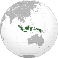
English: Orthographic map of Indonesia |
||||
| врѣмѧ сътворѥниꙗ | |||||
| кладѧꙃь |
своѥ творѥниѥ
|
||||
| творьць | Addicted04 | ||||
| Other versions |
Derivative works of this file: BK Oceania (orthographic projection).png .svg)
|
||||
| SVG genesis |
.svg)
.svg)
.svg)
.svg)
.svg)
.svg)
.svg)
.svg)
.svg)
.svg)
.svg)
.svg)
.svg)
.svg)
.svg)
.svg)
.svg)
.svg)
.svg)
.svg)
.svg)
.svg)
.svg)
.svg)
.svg)
.svg)
.svg)
.svg)
.svg)
.svg)
.svg)
.svg)
.svg)
.svg)
.svg)
.svg)
.svg)
.svg)
.svg)
.svg)
.svg)
.svg)
.svg)
.svg)
.svg)
.svg)
.svg)
.svg)
.svg)
.svg)
.svg)
.svg)
.svg)
.svg)
.svg)
.svg)
.svg)
.svg)
.svg)
.svg)
.svg)
.svg)
.svg)
.svg)
.svg)
.svg)
.svg)
.svg)
.svg)
.svg)
.svg)
.svg)
.svg)

.svg)

.svg)

.svg)
.svg)
.svg)
.svg)
.svg)
.svg)
.svg)


.svg)
.svg)
.svg)
.svg)
.svg)
.svg)
.svg)

.svg)
.svg)
.svg)
.svg)
.svg)
.svg)
.svg)
.svg)
.svg)

.svg)
.svg)
.svg)
.svg)
.svg)
.svg)
.svg)
_without_national_boundaries.svg)
.svg)
.svg)
.svg)
.svg)
.svg)
.svg)

.svg)
.svg)
.png)
.svg)
.svg)
.svg)
.svg)

.svg)
.svg)
.svg)
.svg)
.svg)
.svg)
.svg)
.svg)
.svg)
.svg)
.svg)

.svg)
.svg)
.svg)
.svg)
.svg)
.svg)
.svg)
.svg)
.svg)

.svg)
.svg)

.svg)
.svg)
.svg)
.svg)
.svg)
.svg)
.svg)
.svg)
.svg)
.svg)
.svg)
.svg)
.svg)
.svg)
.svg)
.svg)
.svg)
.svg)
.svg)
.svg)
.svg)
.svg)
.svg)
.svg)
.svg)
.svg)
.svg)
_-_Crimea_disputed.svg)
.svg)
.svg)
.svg)
.svg)
.svg)
.svg)
.svg)
.svg)
.svg)
.svg)
.svg)
_political.svg)
.svg)
.svg)
.svg)
.svg)
_-_Crimea_disputed_-_no_borders.svg)
.svg)
.svg)
.svg)
.svg)
.svg)
.svg)
.svg)
.svg)
.svg)
.svg)
.svg)

.svg)
.svg)
.svg)

.png)
.svg)
.svg)
.svg)
.svg)
.svg)
.svg)
.svg)
.svg)
.svg)
.svg)
.svg)
.svg)
.svg)
.svg)
.svg)
.svg)
.svg)
.svg)
.svg)
.svg)
.svg)
.svg)
.svg)
.svg)
.svg)
.svg)
.svg)
.svg)
.svg)
.svg)
.svg)
.svg)
.svg)
.svg)
.png)
.svg)
.svg)
.svg)
_(orthographic_projection).png)
.svg)
.svg)
.png)
.svg)
.svg)
прощєниѥ
I, the copyright holder of this work, hereby publish it under the following licenses:
сѥ́ дѣ́ло по́дъ прощє́ниѥмь Creative Commons Attribution-Share Alike 3.0 Unported положєно ѥ́стъ
- тꙑ можєши :
- прострѣти – to copy, distribute and transmit the work
- прѣвращати – прѣтворити дѣло
- Under the following conditions:
- attribution – You must give appropriate credit, provide a link to the license, and indicate if changes were made. You may do so in any reasonable manner, but not in any way that suggests the licensor endorses you or your use.
- share alike – ащє жє сѥ дѣло иꙁмѣниши · прѣвратиши или ѥгожє основѣ нѣчьто сътвориши · тъ авлѥно слѣдьствиѥ подъ самомь тѣмь прощєниѥмь или подобьномь ѥмоу положити длъжєнъ ѥси

|
Permission is granted to copy, distribute and/or modify this document under the terms of the GNU Free Documentation License, Version 1.2 or any later version published by the Free Software Foundation; with no Invariant Sections, no Front-Cover Texts, and no Back-Cover Texts. A copy of the license is included in the section entitled GNU Free Documentation License. |
прощєниѥ иꙁбрати можєши
дѣла їсторїꙗ
Click on a date/time to view the file as it appeared at that time.
| дьнь / врѣмѧ | малъ обраꙁъ | мѣра | польꙃєватєл҄ь | опьсаниѥ | |
|---|---|---|---|---|---|
| нꙑнѣщьн҄ь обраꙁъ | 10:31, дєкємврїꙗ 17 числа, 2021 | | 550 × 550 (1,79 MB) | Sette-quattro | newly generated image, higher geographical resolution |
| 11:06, мартїꙗ 27 числа, 2019 |  | 550 × 551 (133 Х҃Б) | Viva Nicolás | Fix map shade | |
| 14:27, октѡврїꙗ 7 числа, 2018 |  | 550 × 551 (133 Х҃Б) | JoKalliauer | Reverted to version as of 04:57, 5 September 2018 (UTC) | |
| 15:02, сєптємврїꙗ 7 числа, 2018 |  | 550 × 551 (159 Х҃Б) | JoKalliauer | added colourshading again | |
| 04:57, сєптємврїꙗ 5 числа, 2018 |  | 550 × 551 (417 Х҃Б) | Hddty | fix some unnecessary line in Australia | |
| 04:37, аѷгоуста 25 числа, 2018 |  | 512 × 513 (185 Х҃Б) | Gunkarta | Correction, including Riau Island Province (Natuna Islands) | |
| 21:46, ноємврїꙗ 7 числа, 2009 |  | 550 × 551 (414 Х҃Б) | Addicted04 | {{Information |Description={{en|1=Orthographic map of Indonesia}} |Source={{own}}{{Inkscape}}{{GFDL-GMT|migration=redundant}} |Author=Addicted04 |Date=2009-11-07 |Permission= |other_versions= }} [[Category:Maps with or |
дѣла польꙃєваниѥ
The following page uses this file:
Global file usage
инꙑ мѣста къдє сѥ дѣло польꙃєвано ѥстъ :
- польꙃєваниѥ въ ace.wikipedia.org
- польꙃєваниѥ въ als.wikipedia.org
- польꙃєваниѥ въ ami.wikipedia.org
- польꙃєваниѥ въ ang.wikipedia.org
- польꙃєваниѥ въ an.wikipedia.org
- польꙃєваниѥ въ ar.wikipedia.org
- إندونيسيا
- بوابة:العالم الإسلامي/دولة مختارة/أرشيف
- بوابة:العالم الإسلامي/دولة مختارة/12
- قائمة الدول ذات السيادة والأقاليم التابعة في آسيا
- قرار مجلس الأمن التابع للأمم المتحدة رقم 86
- مستخدم:جار الله/قائمة صور مقالات العلاقات الثنائية
- العلاقات الأنغولية الإندونيسية
- العلاقات الإندونيسية الكورية الجنوبية
- العلاقات الإريترية الإندونيسية
- العلاقات الإندونيسية السويسرية
- العلاقات الألمانية الإندونيسية
- العلاقات الإندونيسية الليختنشتانية
- العلاقات الإندونيسية البوليفية
- العلاقات الإندونيسية الموزمبيقية
- العلاقات الألبانية الإندونيسية
- العلاقات الإندونيسية البلجيكية
- العلاقات الإثيوبية الإندونيسية
- العلاقات الإندونيسية البيلاروسية
- العلاقات الإندونيسية الطاجيكستانية
- العلاقات الإندونيسية الروسية
- العلاقات الإندونيسية الرومانية
- العلاقات الأرجنتينية الإندونيسية
- العلاقات الإندونيسية الغامبية
- العلاقات الإندونيسية القبرصية
- العلاقات الإندونيسية السيراليونية
- العلاقات الإندونيسية النيبالية
- العلاقات الإندونيسية الليبيرية
- العلاقات التشيكية الإندونيسية
- العلاقات الإندونيسية الميانمارية
- العلاقات الإندونيسية الكندية
- العلاقات الإندونيسية الزيمبابوية
- العلاقات الإندونيسية البالاوية
- العلاقات الإندونيسية المالية
- العلاقات الإندونيسية النيجيرية
- العلاقات اليمنية الإندونيسية
- العلاقات الإندونيسية الفانواتية
- العلاقات الغابونية الإندونيسية
- العلاقات الإندونيسية البنمية
- العلاقات الإندونيسية الكوبية
- العلاقات الإندونيسية الجورجية
- العلاقات الإندونيسية التونسية
- العلاقات الإندونيسية الكورية الشمالية
- العلاقات اليابانية الإندونيسية
- العلاقات الإندونيسية الإيطالية
View more global usage of this file.
.svg)
.svg)