
Дѣло:Chile (orthographic projection).svg

Size of this PNG preview of this SVG file: 550 × 550 пиѯєлъ. Other resolutions: 240 × 240 пиѯєлъ | 480 × 480 пиѯєлъ | 768 × 768 пиѯєлъ | 1.024 × 1.024 пиѯєлъ | 2.048 × 2.048 пиѯєлъ.
источьнъ дѣла обраꙁъ (дѣло SVG · обꙑчьнъ обраꙁъ : 550 × 550 п҃ѯ · дѣла мѣра : 707 Х҃Б)
| Сь видъ Викикладѣ (Wikimedia Commons) съхранѥнъ ѥстъ ⁙ Cѥ ѥгожє опьсаниѥ ѥстъ |
опьсаниѥ
| опьсаниѥ |
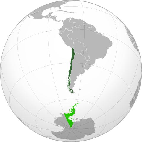
Español: Territorio soberano. Mapa de Chile centrado en Santigo de ChileEnglish: Sovereign territory. Map of Chile centered on Santigo |
||
| врѣмѧ сътворѥниꙗ | (UTC) | ||
| кладѧꙃь | своѥ творѥниѥ | ||
| творьць | Addicted04 (бєсѣда) | ||
| Other versions |
.svg)
|
||
| SVG genesis |
.svg)
.svg)
.svg)
.svg)
.svg)
.svg)
.svg)
.svg)
.svg)
.svg)
.svg)
.svg)
.svg)
.svg)
.svg)
.svg)
.svg)
.svg)
.svg)
.svg)
.svg)
.svg)
.svg)
.svg)
.svg)
.svg)
.svg)
.svg)
.svg)
.svg)
.svg)
.svg)
.svg)
.svg)
.svg)
.svg)
.svg)
.svg)
.svg)
.svg)
.svg)
.svg)
.svg)
.svg)
.svg)
.svg)
.svg)
.svg)
.svg)
.svg)
.svg)
.svg)
.svg)
.svg)
.svg)
.svg)
.svg)
.svg)
.svg)
.svg)
.svg)
.svg)
.svg)
.svg)
.svg)
.svg)
.svg)
.svg)
.svg)
.svg)
.svg)
.svg)
.svg)

.svg)

.svg)

.svg)
.svg)
.svg)
.svg)
.svg)
.svg)
.svg)


.svg)
.svg)
.svg)
.svg)
.svg)
.svg)
.svg)

.svg)
.svg)
.svg)
.svg)
.svg)
.svg)
.svg)
.svg)
.svg)

.svg)
.svg)
.svg)
.svg)
.svg)
.svg)
.svg)
_without_national_boundaries.svg)
.svg)
.svg)
.svg)
.svg)
.svg)
.svg)

.svg)
.svg)
.png)
.svg)
.svg)
.svg)
.svg)

.svg)
.svg)
.svg)
.svg)
.svg)
.svg)
.svg)
.svg)
.svg)
.svg)
.svg)

.svg)
.svg)
.svg)
.svg)
.svg)
.svg)
.svg)
.svg)
.svg)

.svg)
.svg)

.svg)
.svg)
.svg)
.svg)
.svg)
.svg)
.svg)
.svg)
.svg)
.svg)
.svg)
.svg)
.svg)
.svg)
.svg)
.svg)
.svg)
.svg)
.svg)
.svg)
.svg)
.svg)
.svg)
.svg)
.svg)
.svg)
.svg)
_-_Crimea_disputed.svg)
.svg)
.svg)
.svg)
.svg)
.svg)
.svg)
.svg)
.svg)
.svg)
.svg)
.svg)
_political.svg)
.svg)
.svg)
.svg)
.svg)
_-_Crimea_disputed_-_no_borders.svg)
.svg)
.svg)
.svg)
.svg)
.svg)
.svg)
.svg)
.svg)
.svg)
.svg)
.svg)

.svg)
.svg)
.svg)

.png)
.svg)
.svg)
.svg)
.svg)
.svg)
.svg)
.svg)
.svg)
.svg)
.svg)
.svg)
.svg)
.svg)
.svg)
.svg)
.svg)
.svg)
.svg)
.svg)
.svg)
.svg)
.svg)
.svg)
.svg)
.svg)
.svg)
.svg)
.svg)
.svg)
.svg)
.svg)
.svg)
.svg)
.svg)
.png)
.svg)
.svg)
.svg)
_(orthographic_projection).png)
.svg)
.svg)
.svg)
.svg)
I, the copyright holder of this work, hereby publish it under the following licenses:
сѥ́ дѣ́ло по́дъ прощє́ниѥмь Creative Commons Attribution 3.0 Unported положєно ѥ́стъ
- тꙑ можєши :
- прострѣти – to copy, distribute and transmit the work
- прѣвращати – прѣтворити дѣло
- Under the following conditions:
- attribution – You must give appropriate credit, provide a link to the license, and indicate if changes were made. You may do so in any reasonable manner, but not in any way that suggests the licensor endorses you or your use.
The map has been created with the Generic Mapping Tools: https://www.generic-mapping-tools.org/ using one or more of these public-domain datasets for the relief:
|

|
Permission is granted to copy, distribute and/or modify this document under the terms of the GNU Free Documentation License, Version 1.2 or any later version published by the Free Software Foundation; with no Invariant Sections, no Front-Cover Texts, and no Back-Cover Texts. A copy of the license is included in the section entitled GNU Free Documentation License. |
прощєниѥ иꙁбрати можєши
прощєниѥ
сѥ́ дѣ́ло по́дъ прощє́ниѥмь Creative Commons Attribution-Share Alike 3.0 Unported положєно ѥ́стъ
- тꙑ можєши :
- прострѣти – to copy, distribute and transmit the work
- прѣвращати – прѣтворити дѣло
- Under the following conditions:
- attribution – You must give appropriate credit, provide a link to the license, and indicate if changes were made. You may do so in any reasonable manner, but not in any way that suggests the licensor endorses you or your use.
- share alike – ащє жє сѥ дѣло иꙁмѣниши · прѣвратиши или ѥгожє основѣ нѣчьто сътвориши · тъ авлѥно слѣдьствиѥ подъ самомь тѣмь прощєниѥмь или подобьномь ѥмоу положити длъжєнъ ѥси
| Annotations | This image is annotated: View the annotations at Commons |
дѣла їсторїꙗ
Click on a date/time to view the file as it appeared at that time.
| дьнь / врѣмѧ | малъ обраꙁъ | мѣра | польꙃєватєл҄ь | опьсаниѥ | |
|---|---|---|---|---|---|
| нꙑнѣщьн҄ь обраꙁъ | 16:28, маїꙗ 24 числа, 2015 | | 550 × 550 (707 Х҃Б) | Janitoalevic | Added Chilean Claims |
| 18:02, їоунїꙗ 23 числа, 2014 |  | 550 × 550 (711 Х҃Б) | Goran tek-en | antarctic claims removed on request | |
| 20:02, октѡврїꙗ 28 числа, 2011 |  | 550 × 550 (707 Х҃Б) | Addicted04 | new map | |
| 01:01, ноємврїꙗ 2 числа, 2010 |  | 550 × 550 (549 Х҃Б) | Addicted04 | White lines | |
| 00:29, ноємврїꙗ 2 числа, 2010 |  | 550 × 550 (549 Х҃Б) | Addicted04 | Centered version | |
| 23:55, ноємврїꙗ 15 числа, 2009 |  | 541 × 541 (382 Х҃Б) | Shibo77 | Claimed baselines different from latitude-longitudes. | |
| 22:29, сєптємврїꙗ 19 числа, 2009 |  | 541 × 541 (382 Х҃Б) | Addicted04 | {{Information |Description={en}} Location of Chile in orthographic projection. {{legend|DarkGreen|Sovereign territorie.}} {{legend|Lime|Territories in claim.}} {{es}} Ubicación geográfica de Chile en proyección ortográ |
дѣла польꙃєваниѥ
The following page uses this file:
Global file usage
инꙑ мѣста къдє сѥ дѣло польꙃєвано ѥстъ :
- польꙃєваниѥ въ ady.wikipedia.org
- польꙃєваниѥ въ af.wikipedia.org
- польꙃєваниѥ въ ami.wikipedia.org
- польꙃєваниѥ въ ar.wikipedia.org
- польꙃєваниѥ въ as.wikipedia.org
- польꙃєваниѥ въ av.wikipedia.org
- польꙃєваниѥ въ azb.wikipedia.org
- польꙃєваниѥ въ az.wikipedia.org
- польꙃєваниѥ въ az.wiktionary.org
- польꙃєваниѥ въ ba.wikipedia.org
- польꙃєваниѥ въ be.wikipedia.org
- польꙃєваниѥ въ bn.wikipedia.org
- польꙃєваниѥ въ br.wikipedia.org
- польꙃєваниѥ въ bug.wikipedia.org
- польꙃєваниѥ въ ca.wikipedia.org
- польꙃєваниѥ въ ceb.wikipedia.org
- польꙃєваниѥ въ co.wikipedia.org
- польꙃєваниѥ въ en.wikipedia.org
- польꙃєваниѥ въ en.wikinews.org
- Category:Chile
- Template:Chile
- Magnitude 7.7 earthquake strikes Antofagasta, Chile
- Juan Bustos, president of Chilean House of Representatives dies
- Chilean court jails ex-army officers for murdering witness in Croatian arms deal
- Conservative Piñera wins Chile polls, opponent Frei concedes defeat
- Chilean President visits Pichilemu to inaugurate Agustín Ross Cultural Centre
- Chile's President-elect's battle with delinquency becomes personal
- 8.8 magnitude earthquake hits Chile; tsunami warnings issued throughout Pacific rim
- NASA scientist: Chile earthquake may have shifted Earth's axis, shortened day
- Earthquake, tsunami combo caused devastation in Pichilemu, Chile
- British tourists missing in Pichilemu, Chile
- Magnitude 6.9 earthquake hits Chile as president is sworn in
- Power outage affects many areas of Chile
- People from Pichilemu, Chile leave La Cruz Hill
- Seismologist Mario Pardo rebukes notion that Pichilemu, Chile experiencing "seismic swarm"
- 2010 Chile earthquakes: Government confirms 452 dead
- Fishermen find body of child killed by Chile tsunami in Pichilemu
- Body of child killed in tsunami identified by Chilean police
- Sequel of aftershocks hit O'Higgins, Bíobío and Maule regions in Chile
- Pichilemu and Cobquecura, Chile rocked again by aftershocks
- 6.2 magnitude earthquake hits northern Chile
- Rancagua, Chile Servicio Médico Legal boss, Juan Díaz, suspended on Juanita Carey case
- Chile tsunami first reached Pichilemu, SHOA reports
- Wikinews interviews Juana Bustamante, Chilean earthquake survivor from Paniahue
- Chilean President Piñera discontinues "catastrophe state" in O'Higgins, Maule and Bío Bío regions
- Rodeo: Cristóbal Cortina and Víctor Vergara win Chile Championship
- Chilean musicians perform concert for Peralillo, Chile residents
View more global usage of this file.
.svg)
.svg)