
Дѣло:Is-map.PNG
Size of this preview: 276 × 598 пиѯєлъ. Other resolutions: 110 × 240 пиѯєлъ | 329 × 713 пиѯєлъ.
источьнъ дѣла обраꙁъ (329 × 713 п҃ѯ · дѣла мѣра : 27 Х҃Б · MIME тѷпъ : image/png)
| Сь видъ Викикладѣ (Wikimedia Commons) съхранѥнъ ѥстъ ⁙ Cѥ ѥгожє опьсаниѥ ѥстъ |
| опьсаниѥ |
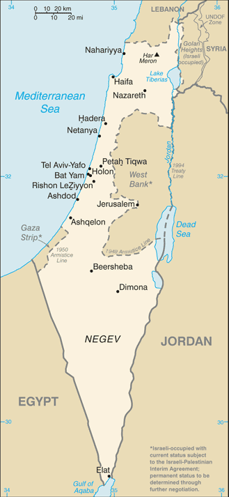
Русский: Карта Израиля |
| врѣмѧ сътворѥниꙗ | (2004) |
| кладѧꙃь | CIA-WF |
| творьць | CIA |
| Other versions |
.png)
This image is in the public domain because it contains materials that originally came from the United States Central Intelligence Agency's World Factbook.
|
 |
дѣла їсторїꙗ
Click on a date/time to view the file as it appeared at that time.
| дьнь / врѣмѧ | малъ обраꙁъ | мѣра | польꙃєватєл҄ь | опьсаниѥ | |
|---|---|---|---|---|---|
| нꙑнѣщьн҄ь обраꙁъ | 07:25, їоунїꙗ 21 числа, 2007 | | 329 × 713 (27 Х҃Б) | Hoshie | Updated map of Israel from the CIA World Factbook, 14 June 07 rev. Src: https://www.cia.gov/library/publications/the-world-factbook/maps/is-map.gif |
| 14:27, їоунїꙗ 16 числа, 2005 |  | 330 × 715 (24 Х҃Б) | Csörföly D | Category:Maps of Israel {{PD-USGov-CIA-PD}} |
дѣла польꙃєваниѥ
There are no pages that use this file.
Global file usage
инꙑ мѣста къдє сѥ дѣло польꙃєвано ѥстъ :
- польꙃєваниѥ въ ar.wikipedia.org
- польꙃєваниѥ въ bg.wikipedia.org
- польꙃєваниѥ въ bn.wikipedia.org
- польꙃєваниѥ въ bs.wikipedia.org
- польꙃєваниѥ въ ca.wikipedia.org
- польꙃєваниѥ въ de.wikipedia.org
- польꙃєваниѥ въ en.wikipedia.org
- History of Israel
- Israeli Declaration of Independence
- Israeli settlement
- Zionism
- Israeli–Palestinian conflict
- Law of Return
- Demographic history of Palestine (region)
- User talk:Theblackbay
- Israel
- Chronology of Aliyah in modern times
- History of Palestine
- Timeline of the name Palestine
- Template:Zionism and the Land of Israel
- Land of Israel
- Module:Location map/data/Israel/doc
- Module:Location map/data/Israel
- User:প্রলয়স্রোত/sandbox
- List of journalists killed during the Israeli–Palestinian conflict
- Israeli war crimes
- Wikipedia:In the news/Posted/February 2005
- Hamas war crimes
- польꙃєваниѥ въ en.wikinews.org
- польꙃєваниѥ въ es.wikipedia.org
- польꙃєваниѥ въ eu.wikipedia.org
- польꙃєваниѥ въ fi.wikipedia.org
- польꙃєваниѥ въ fi.wikivoyage.org
- польꙃєваниѥ въ fr.wikipedia.org
- польꙃєваниѥ въ fr.wikinews.org
- польꙃєваниѥ въ hif.wikipedia.org
- польꙃєваниѥ въ hi.wikipedia.org
- польꙃєваниѥ въ hr.wikipedia.org
- польꙃєваниѥ въ hy.wikipedia.org
- польꙃєваниѥ въ ilo.wikipedia.org
- польꙃєваниѥ въ it.wikinews.org
View more global usage of this file.