
Дѣло:Karte Deutsche Bundesländer (nummeriert).svg

Size of this PNG preview of this SVG file: 443 × 599 пиѯєлъ. Other resolutions: 177 × 240 пиѯєлъ | 355 × 480 пиѯєлъ | 567 × 768 пиѯєлъ | 757 × 1.024 пиѯєлъ | 1.513 × 2.048 пиѯєлъ | 592 × 801 пиѯєлъ.
источьнъ дѣла обраꙁъ (дѣло SVG · обꙑчьнъ обраꙁъ : 592 × 801 п҃ѯ · дѣла мѣра : 110 Х҃Б)
| Сь видъ Викикладѣ (Wikimedia Commons) съхранѥнъ ѥстъ ⁙ Cѥ ѥгожє опьсаниѥ ѥстъ |
| опьсаниѥ |
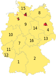
Deutsch: Karte der Bundesrepublik Deutschland mit eingezeichneten Grenzen und alphabetischer Nummerierung der Bundesländer. |
| врѣмѧ сътворѥниꙗ | |
| кладѧꙃь | Erstellt aus Material des gemeinsamen Datenangebotes aus dem gemeinsamen Portal der statistischen Ämter des Bundes und der Länder (DeStatis). [1] |
| творьць | David Liuzzo |
| Permission (Reusing this file) |
сѥ́ дѣ́ло по́дъ прощє́ниѥмь Creative Commons Attribution-Share Alike 2.0 Germany положєно ѥ́стъ
 |
| Other versions |
|
| SVG genesis | This map was created with Adobe Illustrator. |
.svg)

.svg)
.svg)
дѣла їсторїꙗ
Click on a date/time to view the file as it appeared at that time.
| дьнь / врѣмѧ | малъ обраꙁъ | мѣра | польꙃєватєл҄ь | опьсаниѥ | |
|---|---|---|---|---|---|
| нꙑнѣщьн҄ь обраꙁъ | 11:15, мартїꙗ 16 числа, 2016 | | 592 × 801 (110 Х҃Б) | Roman Poulvas | New Map of States of Germany (with Area States & City States) |
| 12:14, октѡврїꙗ 16 числа, 2006 |  | 592 × 801 (110 Х҃Б) | David Liuzzo | Minor fixes; same licensing applies | |
| 17:36, октѡврїꙗ 14 числа, 2006 |  | 592 × 801 (110 Х҃Б) | David Liuzzo | {{Information| |Description= {{de|Karte der Bundesrepublik Deutschland mit eingezeichneten Grenzen und alphabetischer Nummerierung der Bundesländer.}} |Source= Erstellt aus Material des gemeinsamen Datenangebotes au |
дѣла польꙃєваниѥ
The following page uses this file:
Global file usage
инꙑ мѣста къдє сѥ дѣло польꙃєвано ѥстъ :
- польꙃєваниѥ въ af.wikipedia.org
- польꙃєваниѥ въ als.wikipedia.org
- польꙃєваниѥ въ an.wikipedia.org
- польꙃєваниѥ въ ar.wikipedia.org
- польꙃєваниѥ въ ast.wikipedia.org
- польꙃєваниѥ въ ba.wikipedia.org
- польꙃєваниѥ въ be-tarask.wikipedia.org
- польꙃєваниѥ въ bg.wikipedia.org
- польꙃєваниѥ въ br.wikipedia.org
- польꙃєваниѥ въ bs.wikipedia.org
- польꙃєваниѥ въ ca.wikipedia.org
- польꙃєваниѥ въ ce.wikipedia.org
- польꙃєваниѥ въ cy.wikipedia.org
- польꙃєваниѥ въ da.wikipedia.org
- польꙃєваниѥ въ de.wikipedia.org
- польꙃєваниѥ въ de.wikibooks.org
- польꙃєваниѥ въ de.wikinews.org
- польꙃєваниѥ въ dsb.wikipedia.org
- польꙃєваниѥ въ en.wikipedia.org
- польꙃєваниѥ въ es.wikipedia.org
- польꙃєваниѥ въ ext.wikipedia.org
- польꙃєваниѥ въ ff.wikipedia.org
- польꙃєваниѥ въ fi.wikipedia.org
- польꙃєваниѥ въ frr.wikipedia.org
- польꙃєваниѥ въ fr.wikipedia.org
- польꙃєваниѥ въ fy.wikipedia.org
- польꙃєваниѥ въ gn.wikipedia.org
- польꙃєваниѥ въ gv.wikipedia.org
- польꙃєваниѥ въ he.wikipedia.org
View more global usage of this file.
.svg)
.svg)